Ripple
Project
Change begins with the smallest splash
Glacier Track
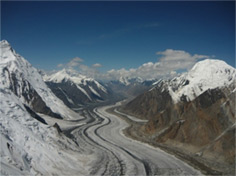


A team from Purdue University led by Professor Jon Harbor is on the hunt for glacial moraines - tracks left behind from moving glaciers. These moraines contain geological information that scientists can use to help understand past and current climate change. This project helps scientists locate glacial moraines, across the globe, which in turn, contributes to their understanding on how climate has varied in the past. This knowledge is then used to understand and predict the effect of current and future climate change on glaciers.
Glaciers recede at varying rates across the world. When glaciers recede they leave behind a puzzle for scientists to piece together by mapping the distribution of sediment (soil and rock), analyzing sediment samples, and determining the age of rocks deposited by glaciers. Glaciers are great indicators of the current climate because they shrink or grow to reflect the changing temperatures and precipitation. Currently, glaciers around the world are getting smaller, quicker and are leaving behind distinct geographical features that allow researchers to map their path. These features are known as moraines.
Participants in this project will utilize Google Earth to focus on specific locations and look for evidence of glacial moraines. Your findings could help lead research expeditions in the future and help direct scientists to where soil and rocks should be sampled. The analysis is tricky because glaciers don’t consistently recede or grow, but rather convulse to create overlapping paths.
Utilizing Google Earth, participants will be able to identify areas showing evidence of moraines. In the tutorials, you will learn about glaciers, find what types of features signify a moraine, and how to record your findings. By observing these glacier tracks scientists can map out the glacier’s path and create simulations that predict the glacial recession rate and how that might impact the Earth’s climate over time.
Currently, the research team has scientists mapping areas in Central Asia and the Tibetan plateau. Read more about our current findings in the ‘Latest News’ tab above. You can read more about Dr. Harbor and his research here: www.eaps.purdue.edu/people/faculty-pages/harbor.html
Glacier Track Tutorial
I’m interested! What Do I Do Now?
- If you don’t have Google Earth, Download Google Earth to your computer. You will see a Download button to click. This link http://www.google.com/earth/index.html will take you to the Google Earth page: providing video tutorials and answer any questions you might have about downloading the application.
- View the above videos. Learn about glaciers, moraines, Google Earth and how they all work together to bring researchers at Purdue important data for their climate research.
- Pick your location. Glaciers cover the world and can be found on nearly every continent, on high altitudes or in high latitudes. Be sure to notice where the researchers are focusing their search (Currently they are in the Tian Shan and Altai, two vast mountain ranges in Central Asia).
- Hunt for evidence of moraines. The tutorial showed you what to look for, now it’s up to you to search the area and mark any evidence of glacial moraines you see.
- Mark and record the moraine location in the data boxes. Once you find a moraine pin the four corners surrounding it with the Google Earth Pins. View the pin properties to find the X and Y coordinates to input in the Start Tracking form.
- Connect with others. Check out Join the Discussion and share your thoughts or ask a question OR see what the Researchers are up to at the Latest News tab and share your thoughts.
What is a glacier?
Glaciers are large, mobile ice masses formed by the accumulation and compaction of snow and ice.. On our planet glaciers was much bigger in the past. At the end of the last Ice Age (almost 20 000 years ago), large Ice Sheets covered parts of North America and Eurasia. Today glaciers are much smaller but ice sheets still exist on Greenland and Antarctica. They cover approximately 10% of the Earth’s land area and account for 75% of the world’s freshwater. The ice near the top of the glacier is rigid, while the ice underneath transforms to a flowing plasticity due to the pressure exerted from the higher ice layers. This high pressure transformation also is the reason glacial ice often exhibits a blue hue. The ice becomes extremely dense under the pressure exerted from the ice layers. Gravity and slope angle cause glaciers to move like a conveyor belt; picking up and eroding anything that’s in their path.
What is a moraine?
Moraines are landforms formed by glaciers and are an accumulation of unconsolidated glacial debris (also called till) that is left behind as the glacier contracts (recedes). They are distinct land features seen as a mound, ridge, or sometime spread out sheet. The debris left from the glacier is usually observed in bands that show that path of the glacier. Glaciers leave a unique landscape consisting of till, shaped by the trajectory and a trail of its movements. Multiple moraines may develop as the glacier advances and retreats over time.
Various types of moraines can be formed and are identified based on their relation to the glacier:
- Lateral moraines: Run along the sides of a glacier consisting of unconsolidated glacier debris. They are usually seen as high ridges.
- Medial moraines: Run down the middle of a glacier and is created when two glaciers meet each other. The debris between them is pressed together and a ridge develops that runs down the middle of the valley floor, and not usually seen until the glacier recedes due to the ice cover at the top of the joining glaciers.
- Terminal moraines: Are found at the ‘snout’ or end of a glacier. A ridge of unconsolidated debris is formed and usually reflects the shape of the glacier. The height and size of the ridge formed depends on the phase of the glacier and how long it remains in place.
If you have not viewed the tutorial videos please do so before you begin tracking.
To identify moraines, we need your help! Once several trackers identify a moraine near the same region our team will verify your findings. Please enter the X and Y coordinates for the four points of a rectangle surrounding the moraine you tracked in Google Earth. If you feel like an expert you can also tell us whether the moraine is old or young, but this is not required. Feel free to enter as many moraines as you have time to track. Watch the Latest News tab for updates on moraines that have been verified.